Bohol Island is the main island of Bohol Province in the Visayas.
It lies southeast from Cebu Island across Cebu Strait (in some references called Bohol Strait) and southwest from Leyte Island, separated by the Camotes Sea and Canigao Channel. Bohol is also located north of Mindanao with Bohol Sea between them.
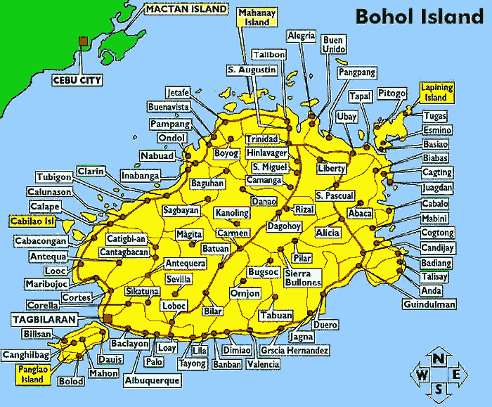
With a land area of 3269 km² and a coastline 261 km long, Bohol is the tenth largest island of the Philippines. The main island is surrounded by about 70 smaller islands, the largest of which are Panglao Island facing Tagbilaran City in the southwest and Lapining Island in the northeast. The Island of Bohol is oval-shaped mainland surrounded with 73 smaller islands, having a gently rolling terrain, ideal for commercial and industrial site development. Bohol's mountainous interior is home to rare and endangered flora and fauna. At certain points, hills drop steeply to the coast from a maximum elevation of 870 meters above sea level. The interior uplands are fit for agro-forestry and high value agricultural production. The central and northern lowlands have also fertile grounds and abundant water supply. Over a hundred caves have been identified, the biggest of which is found in the eastern part which makes Bohol ideal for spelunking adventures.
The Chocolate Hills are considered one of Philippine's natural wonders and Bohol is often referred to as the Jewel of the Philippines. They are hills made of limestone leftover from coral reefs during the ice age when the island was submerged.
They turn brown during the summer, hence their name.
Most beaches are of white sand.
The sand is often of such high quality that it is exported to other beaches in the world. The most well known of these beaches are in Panglao Island, and there, numerous islets have similar, yet untouched and pristine beaches.
There are four main rivers that run through Bohol with Loboc River being the most famous for it's river cruises, running from the center of the island to the southeastern coast. The largest, Inabanga River, runs in the northwestern part of the province. The Abatan River in the southwest, and Ipil river in the north.
Numerous waterfalls and caves are scattered across the island, including the beautiful Mag-Aso falls in Antequera. Mag-Aso means smoke in the native tongue. The water is cool and often creates a mist in humid mornings which can hide the falls.
It lies southeast from Cebu Island across Cebu Strait (in some references called Bohol Strait) and southwest from Leyte Island, separated by the Camotes Sea and Canigao Channel. Bohol is also located north of Mindanao with Bohol Sea between them.
With a land area of 3269 km² and a coastline 261 km long, Bohol is the tenth largest island of the Philippines. The main island is surrounded by about 70 smaller islands, the largest of which are Panglao Island facing Tagbilaran City in the southwest and Lapining Island in the northeast. The Island of Bohol is oval-shaped mainland surrounded with 73 smaller islands, having a gently rolling terrain, ideal for commercial and industrial site development. Bohol's mountainous interior is home to rare and endangered flora and fauna. At certain points, hills drop steeply to the coast from a maximum elevation of 870 meters above sea level. The interior uplands are fit for agro-forestry and high value agricultural production. The central and northern lowlands have also fertile grounds and abundant water supply. Over a hundred caves have been identified, the biggest of which is found in the eastern part which makes Bohol ideal for spelunking adventures.
The Chocolate Hills are considered one of Philippine's natural wonders and Bohol is often referred to as the Jewel of the Philippines. They are hills made of limestone leftover from coral reefs during the ice age when the island was submerged.
They turn brown during the summer, hence their name.
Most beaches are of white sand.
The sand is often of such high quality that it is exported to other beaches in the world. The most well known of these beaches are in Panglao Island, and there, numerous islets have similar, yet untouched and pristine beaches.
There are four main rivers that run through Bohol with Loboc River being the most famous for it's river cruises, running from the center of the island to the southeastern coast. The largest, Inabanga River, runs in the northwestern part of the province. The Abatan River in the southwest, and Ipil river in the north.
Numerous waterfalls and caves are scattered across the island, including the beautiful Mag-Aso falls in Antequera. Mag-Aso means smoke in the native tongue. The water is cool and often creates a mist in humid mornings which can hide the falls.
Click image to zoom
Location. Bohol is an island province in the Visayas. It lies southeast from Cebu across Bohol Strait and southwest from Leyte, separated by the Camotes Sea and Canigao Channel. Bohol is also located north of Mindanao with Bohol Sea between them.
Features. With a land area of 3269 km² and a coastline 261 km long, Bohol is the tenth largest island of the Philippines. The main island is surrounded by about 70 smaller islands, the largest of which are Panglao Island facing Tagbilaran City in the southwest and Lapinig Island in the northeast.
The terrain of Bohol is basically rolling and hilly and about half the island is covered in limestone. Near the outer areas of the island are low mountain ranges. The interior is a large plateau with irregular landforms.
Near Carmen can be found the major tourist draw of the province, the Chocolate Hills. The more than 1,200 uniformly cone-shaped limestone hills were named that way because in the summer, the grass growing on the hills turn brown, making the landscape look like it had chocolate mounds all over. The Chocolate Hills is found on the provincial seal of Bohol.
Climate. Unlike Luzon and the northern part of Visayas, Bohol is mostly unaffected by the numerous typhoons that hit the country. The weather is mostly mild all year round. When typhoons do hit the island, they usually cross quickly and are no longer powerful, their energy dissipated by the mountains in Leyte and Samar.
From November to April, the northeast monsoon (amihan) prevails. Except for a rare shower, this is the mildest time of the year. Daytime temperatures average 28°C, cooling down at night to around 25°C. The summer season from May to July brings higher temperatures and very humid days. From August to October is the southwest monsoon (habagat). The weather during this season is not very predictable, with weeks of calm weather alternating with rainy days. It can rain any day of the year, but you wil have more chance for a heavy shower from November to January. If you want to see the Chocolate Hills in their "Chocolate" color, you will have to go there during the "Summer".
From November to April, the northeast monsoon (amihan) prevails. Except for a rare shower, this is the mildest time of the year. Daytime temperatures average 28°C, cooling down at night to around 25°C. The summer season from May to July brings higher temperatures and very humid days. From August to October is the southwest monsoon (habagat). The weather during this season is not very predictable, with weeks of calm weather alternating with rainy days. It can rain any day of the year, but you wil have more chance for a heavy shower from November to January. If you want to see the Chocolate Hills in their "Chocolate" color, you will have to go there during the "Summer".
Executive Brief:
Location:
Capital:
Cities:
Municipalities:
Barangays:
Land Area:
Province:
City:
Language/Dialects:
Literacy Rate:
Labor Force:
Climate:
Average Temperature:
Arable area:
Sectoral Establishments: (DTI registered as of June'98)
Capital:
Cities:
Municipalities:
Barangays:
Land Area:
Province:
City:
Language/Dialects:
Literacy Rate:
Labor Force:
Climate:
Average Temperature:
Arable area:
Sectoral Establishments: (DTI registered as of June'98)
Region 8, 803 km.south of Manila,79 km southeast of Cebu
Tagbilaran City
1 (Tagbilaran City)
47
1,109
4,117.26 square kilometers
Population
1,230,110 (2007 Census)
92,297 (2007 Census)
Boholano, English, Tagalog, Chinese
93%
404,000 (1996)
Generally fair 29°C
256,400 hectares
Manufacturing: 762
Service: 2,345
Wholesale/Retail: 5,925
Total: 9,032
Tagbilaran City
1 (Tagbilaran City)
47
1,109
4,117.26 square kilometers
Population
1,230,110 (2007 Census)
92,297 (2007 Census)
Boholano, English, Tagalog, Chinese
93%
404,000 (1996)
Generally fair 29°C
256,400 hectares
Manufacturing: 762
Service: 2,345
Wholesale/Retail: 5,925
Total: 9,032
Industrial Establishments:
Leading Non-Traditional Exports:
Leading Domestic Items Traded:
Leading Domestic Trade Partner:
Land Classification:
Leading Non-Traditional Exports:
Leading Domestic Items Traded:
Leading Domestic Trade Partner:
Land Classification:
Limestone mining, cassava start/glucose plant, galvanized iron sheets factory, soft drink bottling plant, frozen prawn, food processing, ice plant, handicraft, metalcraft, furniture
Prawns, baskets, woven raffia
GI sheets, limestone, handicraft, marine products, rice, banana, cattle, hog, mangoes, fish, copra
Visayas, Mindanao
Certified alienable and disposable: 310,455 has.
Prawns, baskets, woven raffia
GI sheets, limestone, handicraft, marine products, rice, banana, cattle, hog, mangoes, fish, copra
Visayas, Mindanao
Certified alienable and disposable: 310,455 has.
Classified forest:
Agri/Aqua Products
Power Capacity:
Water Supply (City):
Road Network:
Seaports:
Airport Domestic:
Land Transportation:
Agri/Aqua Products
Power Capacity:
Water Supply (City):
Road Network:
Seaports:
Airport Domestic:
Land Transportation:
101,271 has.
Rice, corn, coconut, root crops, vegetables, fruits, poultry, fish, prawns, crabs, seaweeds
93.5 MW
19,000 cubic meters daily
5,385 kilometers
Domestic Base port: Tagbilaran City
Terminal ports: Tubigon, Jagna, Ubay, Talibon
Subports: Catagbacan, Getafe
Municipal fish ports: 15, Private ports:2
Tagbilaran City Airport
Taxicabs: 30
Bus Companies: 1,010
Vehicles for hire: 4,716
Trucking services: 9
Communications Telephone lines:
Cellular phone firms:
Telecommunication companies:
Radio stations (AM, FM):
TV/Cable stations:
Messengerial/Courier:
Post Offices:
Newspapers:
Internet service providers:
Trade publication:
Cellular phone firms:
Telecommunication companies:
Radio stations (AM, FM):
TV/Cable stations:
Messengerial/Courier:
Post Offices:
Newspapers:
Internet service providers:
Trade publication:
12,200
2
6
5
5
7
49
3
3
1
2
6
5
5
7
49
3
3
1
Financial Systems
Commercial banks:
Development banks:
Government banks:
Cooperative bank:
Savings banks:
Rural banks:
ATM facilities:
International credit card available:
Lending firms:
Pawnshops:
Commercial banks:
Development banks:
Government banks:
Cooperative bank:
Savings banks:
Rural banks:
ATM facilities:
International credit card available:
Lending firms:
Pawnshops:
20
21
2
1
2
7
7
6
65
70
